


I really love maps.
I can spend a long time looking at them, especially old ones, where the borders do not yet quite resemble the ones we know today.
But what I enjoy most are those moments when some strange line on a map suddenly turns out to hide an interesting and unexpected story.
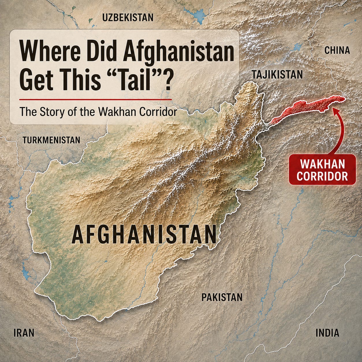
There is one such line on the map of Afghanistan.
From the country’s northeast, a long narrow “tail” stretches out between Tajikistan and Pakistan. It runs through the Pamirs all the way to China.
This is the Wakhan Corridor.
And the first question that comes to mind when you look at the map is:
where did it come from?
First There Was Wakhan
One important clarification: Wakhan itself was not invented in the nineteenth century.
It is an old historical region of Badakhshan through which routes connecting Central Asia, Kashgar, Badakhshan and the Indian subcontinent had passed for centuries.
The Wakhi people lived there and still do today, while farther east, high in the Pamirs, live Kyrgyz pastoralists.
So:
Wakhan is ancient.
The Wakhan Corridor in its present form is relatively new.
And its appearance is connected to the Great Game.
When Two Empires Began Moving Towards Each Other
During the nineteenth century, the Russian Empire was gradually expanding southwards through Central Asia.
The British Empire watched this from India and became increasingly nervous.
For London, India was one of the empire’s most important possessions, so Russia’s advance towards its northern frontiers was seen as a potential threat.
This gave rise to a long rivalry between Russia and Britain for influence in Central Asia, which later acquired the rather elegant name the Great Game.
And Afghanistan found itself literally in the middle.
Amir Abdur Rahman Khan even compared his country to a poor goat being watched at the same time by a lion and a bear - Britain and Russia.
As far as I am concerned, that is a very accurate image.
How the “Tail” Appeared
The first important step came in 1872-1873, when London and St Petersburg were negotiating Afghanistan’s northern boundaries.
The British insisted that Badakhshan and Wakhan should belong to the Afghan sphere.
Russia eventually agreed.
But farther east, in the Pamirs, the border still remained uncertain.
The final shape of that same “tail” appeared in 1895, when the Russian and British empires agreed on the division of their spheres of influence in the Pamirs.
The logic was very simple:
to the north - Russian possessions;
to the south - British India;
between them - a narrow strip of Afghanistan.
In this way, Wakhan became a kind of geopolitical “buffer”, preventing the Russian Empire and British India from sharing a direct border.
And that is why Afghanistan still has this strange, long “tail” on the map today.
Interestingly, the Afghan emir himself was not particularly excited about this territorial gift.
Wakhan was incredibly remote, poor, mountainous and difficult to defend.
For Kabul, it was more of a responsibility than a valuable acquisition.
And at the End - China
The story becomes even more interesting if you follow this “tail” all the way to its end.
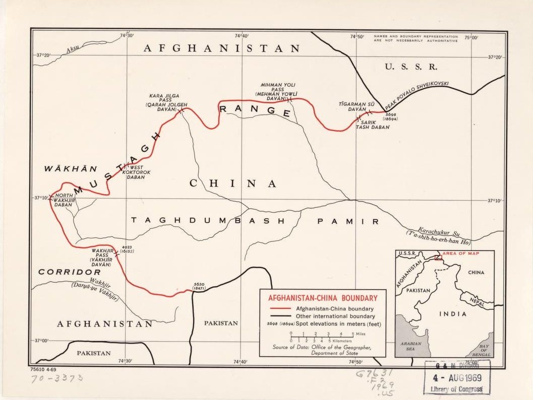
There, Afghanistan suddenly runs into China.
The Afghan-Chinese border is very short - about 90 kilometres. It passes through the high Pamirs, including the area around the Wakhjir Pass at an altitude of almost 5,000 metres.
And this is where one of my favourite geographical oddities begins.
There is a border between Afghanistan and China.
But there is no normal international border crossing.
In other words, the two countries are neighbours on the map, but you cannot simply get into a car, drive to the border, show your passport and continue into China.
Between them lie mountains, glaciers, extreme altitude and almost no transport infrastructure.
A Three-and-a-Half-Hour “Jump”
And now for the best detail.
Afghanistan uses UTC+4:30.
China, despite its enormous size, officially uses a single time zone - UTC+8.
So if the Wakhjir crossing were open and you could simply walk across the border, you would immediately have to move your clock:
3 hours and 30 minutes forward!
12:00 in Afghanistan - and already 15:30 in China.
This is the largest official time difference across a land border between two countries anywhere in the world.
It feels especially strange here - in almost uninhabited mountains where there is, in practice, no normal border crossing at all.
A Buffer They Now Want to Turn into a Corridor
There is one more nice irony in this story.
At the end of the nineteenth century, Wakhan was left between the great powers so that it would separate them.
Today, Afghanistan is trying to use it for exactly the opposite purpose - to connect with China.
In recent years, a road has been actively developed through Wakhan towards the Chinese border.
But a road reaching the border and an open international transport corridor are still very different things.
China has not opened an ordinary crossing through Wakhjir.
So the geopolitical “buffer” of the nineteenth century may theoretically one day become a trade corridor of the twenty-first.
What I like most about this story is that you can first simply see it.
You do not need to know any dates, treaties or names of diplomats.
You only need to look at a map of Afghanistan and ask:
why does it have such a strange “tail”?
And behind this small geographical oddity, the Great Game suddenly opens up before you: the rivalry of two empires, the high Pamirs, a short border with China without a normal crossing - and three and a half hours that could theoretically be jumped in a single step.
British India is long gone. So is the Russian Empire.
But the geopolitical buffer created between them remains - a narrow Afghan “tail” that still stretches all the way to China.